
The Three Volcanic Cones of Mount Kilimanjaro: Kibo, Mawenzi and Shira
Introduction: Understanding the Three Cones of Mount Kilimanjaro
Mount Kilimanjaro is one of Africa’s most spectacular natural landmarks. Located in northern Tanzania, close to the Kenyan border, it rises to 5,895 metres above sea level, making it the highest mountain in Africa.
Although many people refer to Kilimanjaro as a single mountain, it is actually a volcanic massif formed by three major volcanic cones: Kibo, Mawenzi and Shira. These formations developed during different periods of volcanic activity and have distinct geological characteristics, elevations and landscapes.
The three cones are arranged broadly from west to east. Shira is the oldest and most eroded, Mawenzi is known for its rugged peaks and sharp ridges, while Kibo is the highest and youngest volcanic cone, carrying Uhuru Peak, the highest point in Africa.
Understanding the three volcanic cones provides an interesting insight into the geological history of Kilimanjaro and the natural features that make it such a popular destination for mountain climbing and adventure tourism.
1. Kibo: The Highest and Youngest Volcanic Cone (5,895 Metres)
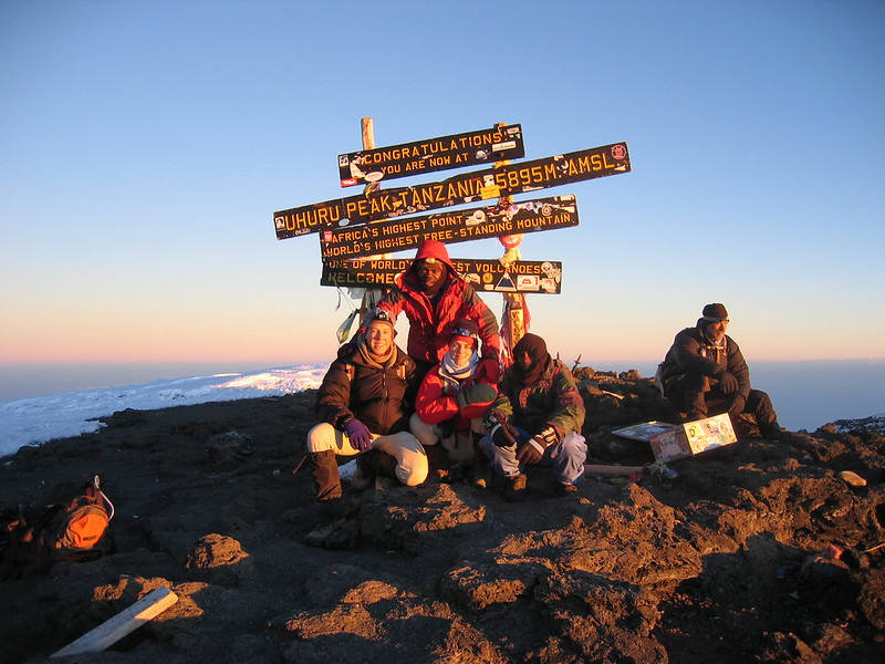
Kibo is the central and highest of Kilimanjaro’s three volcanic cones. It is home to Uhuru Peak, which stands at 5,895 metres above sea level and represents the highest point on the African continent.
Unlike Mawenzi and Shira, which are considered extinct, Kibo is classified as dormant. It has not experienced a known eruption in modern times, although geothermal activity, including fumaroles, has been observed within its crater.
Kibo has a broad, relatively smooth volcanic summit compared with the rugged appearance of Mawenzi. Its upper slopes contain volcanic rock, ash, snow and remaining glaciers. The summit area includes a large crater, with Reusch Crater and the Inner Ash Pit among its notable geological features.
The summit rim contains several important landmarks, including Uhuru Peak and Stella Point. Climbers approaching the summit from popular routes such as Machame, Lemosho, Marangu and Rongai eventually reach the upper slopes of Kibo.
The final ascent usually takes place at night, allowing trekkers to approach the summit around sunrise. Reaching Uhuru Peak is the ultimate goal of most Mount Kilimanjaro climbing expeditions.
Important features of Kibo:
- Highest elevation: 5,895 metres.
- Geological status: Dormant volcanic cone.
- Home to Uhuru Peak, Africa’s highest point.
- Contains a large summit crater and inner ash pit.
- Has remaining glaciers and ice formations.
- The principal summit destination for Kilimanjaro trekkers.
Uhuru Peak: The Highest Point on Kibo
Uhuru Peak is located on the southern rim of Kibo’s summit crater. The name Uhuru means freedom in Swahili. It is the destination that attracts thousands of climbers who travel to Tanzania to experience the challenge of reaching Africa’s highest point.
From the summit, climbers can enjoy spectacular views across the surrounding landscape, weather permitting. The experience of standing at 5,895 metres is a memorable achievement and the highlight of a Kilimanjaro hiking adventure.
2. Mawenzi: The Rugged and Jagged Volcanic Cone (5,149 Metres)
Mawenzi is the second-highest volcanic cone of Mount Kilimanjaro, reaching approximately 5,149 metres above sea level. It is located east of Kibo and is particularly famous for its dramatic appearance.
Unlike Kibo’s relatively broad summit, Mawenzi has a rugged landscape featuring sharp pinnacles, steep ridges, rocky towers and deep valleys. Millions of years of erosion have shaped its volcanic formations into one of the most distinctive mountain landscapes in East Africa.
Mawenzi is classified as an extinct volcanic cone. Its geological structure is heavily eroded, and its summit is much more challenging to access than Kibo.
The peak is named after its distinctive rugged profile and has several prominent rock formations. Its highest point is commonly identified as Hans Meyer Peak.
Mawenzi is separated from Kibo by a high-altitude area known as the Saddle Plateau. This broad landscape lies at approximately 4,400 metres and provides a remarkable contrast between the two volcanic formations.
The Rongai Route offers some of the most memorable views of Mawenzi. Trekkers using this route can appreciate its rugged peaks, particularly around Mawenzi Tarn, a scenic high-altitude campsite located beneath the dramatic volcanic walls.
Unlike the standard trek to Uhuru Peak, climbing Mawenzi requires technical mountaineering skills. Its steep rock faces and exposed ridges make it unsuitable for ordinary trekking.
Important features of Mawenzi:
- Elevation: Approximately 5,149 metres.
- Geological status: Extinct volcanic cone.
- Located east of Kibo.
- Known for sharp pinnacles and rugged ridges.
- Separated from Kibo by the Saddle Plateau.
- Offers dramatic scenery along the Rongai Route.
- Requires technical climbing skills to reach its summit.
Mawenzi Tarn: A Scenic Highland Landmark
Mawenzi Tarn is one of the most attractive high-altitude locations on the eastern side of Kilimanjaro. Situated beneath Mawenzi’s dramatic rock formations, it provides trekkers with impressive views of the mountain’s rugged volcanic structure.
The campsite is particularly associated with the Rongai Route and offers an opportunity to appreciate the contrast between Mawenzi’s sharp peaks and Kibo’s smoother volcanic summit.
3. Shira: The Oldest and Most Eroded Volcanic Cone (Approximately 3,962 Metres)
Shira is the oldest of Kilimanjaro’s three major volcanic cones. Located on the western side of the mountain, it has undergone extensive erosion and a major summit collapse, leaving behind the broad high-altitude landscape known today as the Shira Plateau.
Unlike Kibo and Mawenzi, Shira no longer retains its original volcanic summit. Much of its former structure collapsed, creating a large caldera-like depression. Subsequent volcanic activity, particularly from Kibo, helped reshape and partly cover the older volcanic landscape.
The remaining western and southern rims form important features of the Shira Plateau, which is one of the most scenic areas on Mount Kilimanjaro.
The plateau is characterised by open grassland, rocky formations and high-altitude vegetation. Climbers using the Lemosho and Shira routes pass through this landscape, enjoying expansive views of Kibo and the surrounding mountain environment.
Shira is classified as an extinct volcanic centre. Its geological history makes it particularly interesting to visitors who want to understand how Kilimanjaro developed over millions of years.
Important features of Shira:
- Approximate elevation: 3,962 metres.
- Geological status: Extinct and heavily eroded volcanic cone.
- Located on the western side of Kilimanjaro.
- Its former summit collapsed, forming a caldera.
- Now represented by the Shira Plateau and remaining ridges.
- Provides access to the mountain through the Lemosho and Shira routes.
- Offers wide panoramic views of Kibo and the surrounding landscapes.
Shira Plateau: A Landscape Formed by Ancient Volcanic Activity
The Shira Plateau is one of the most remarkable geological features of Mount Kilimanjaro. It represents the remains of the ancient Shira volcanic structure and provides a broad, open landscape for hikers.
The plateau is particularly attractive during the early stages of the Lemosho and Shira climbing routes. Trekkers can enjoy open mountain scenery, unique high-altitude vegetation and impressive views towards Kibo.
It is also an excellent location for appreciating the scale of Kilimanjaro’s volcanic massif before ascending towards the higher slopes.
The Saddle Plateau: Connecting Kibo and Mawenzi
One of the most interesting geographical features between Kilimanjaro’s volcanic cones is the Saddle Plateau. This high-altitude landscape lies between Kibo and Mawenzi at approximately 4,400 metres above sea level.
The Saddle is a broad, relatively open area characterised by alpine vegetation, volcanic soil and exposed mountain terrain. It offers a dramatic contrast between the smooth volcanic slopes of Kibo and the rugged rock formations of Mawenzi.
Trekkers using the Rongai and Marangu routes may experience parts of this high-altitude landscape as they approach Kibo.
The Saddle is also important from a geological perspective because it demonstrates how the volcanic structures developed alongside one another and eventually became part of one large mountain massif.
Comparing the Three Volcanic Cones of Kilimanjaro
| Volcanic cone | Approximate elevation | Geological status | Main characteristics |
|---|---|---|---|
| Kibo | 5,895 m | Dormant | Highest cone, crater and Uhuru Peak |
| Mawenzi | 5,149 m | Extinct | Jagged peaks, pinnacles and steep ridges |
| Shira | 3,962 m | Extinct | Ancient collapsed cone and Shira Plateau |
How Were the Three Volcanic Cones Formed?
The formation of Mount Kilimanjaro is connected to the geological processes associated with the East African Rift System. Movements and stretching within the Earth’s crust created conditions that allowed magma to rise towards the surface and produce successive volcanic eruptions.
Over millions of years, volcanic materials including lava, ash and other deposits accumulated to form the mountain’s three major volcanic centres.
Shira developed first and eventually experienced a major collapse of its summit. Volcanic activity later developed around Mawenzi and Kibo, with Kibo becoming the highest and youngest of the three cones.
Erosion, volcanic deposits and glacial activity have continued to reshape the mountain. The result is the remarkable landscape visible today, with its broad summit, jagged volcanic peaks, high-altitude plateaux and deep valleys.
Which Kilimanjaro Routes Offer Views of the Three Cones?
Climbers can appreciate different volcanic features depending on the route they choose.
Lemosho Route: This route crosses the western side of the mountain and offers excellent opportunities to explore the Shira Plateau before ascending towards Kibo.
Shira Route: Approaching from the western side, this route also crosses the Shira Plateau and provides views of the mountain’s ancient volcanic landscape.
Rongai Route: This northern approach offers memorable views of Mawenzi, especially around Mawenzi Tarn and the Saddle Plateau.
Marangu Route: The route approaches Kibo from the eastern side and passes through the high-altitude terrain between Kibo and Mawenzi.
Northern Circuit Route: This longer route circles much of the mountain and provides varied views of Kibo, Shira and the surrounding volcanic landscapes.
Although all standard summit routes ultimately approach Kibo, each offers a different opportunity to appreciate Kilimanjaro’s geological features.
Experience the Three Volcanic Cones on a Mount Kilimanjaro Climbing Adventure
Mount Kilimanjaro is much more than Africa’s highest mountain. It is a remarkable volcanic massif whose three major cones tell the story of millions of years of geological activity.
From the ancient and eroded Shira Plateau to the dramatic pinnacles of Mawenzi and the towering summit of Kibo, each volcanic formation contributes to the mountain’s extraordinary landscape.
Whether you are interested in geology, photography, mountain hiking or simply reaching the Roof of Africa, exploring Kilimanjaro offers an unforgettable adventure.
Choose from the Lemosho, Machame, Marangu, Rongai or Northern Circuit routes and discover the landscapes surrounding these three remarkable volcanic formations.
Contact our team today to plan your Mount Kilimanjaro climbing adventure and experience the spectacular volcanic landscapes of northern Tanzania.